Saturday, February 14, 2015

Dr. W.W. Jones & Family - Salt River Recreation Area

Lately I've been snooping around in a website called Chronicling America set up by the Library of Congress. I ran into the site by following the Google+ site "Phoenix, Arizona Historical Images".  The Google+ site posts lots of interesting historical images and notes.  I decided to do some research on some East Valley pioneers who didn't fit into the typical history book profile.  The following accounts are mostly taken from newspaper articles found in Chronicling America.

Several of the old and existing landmarks around the East Valley are named after folks from the late 1800's and early 1900's.  One of these pioneers was Dr. W.W. Jones.  He was born and educated as a doctor back east in Maryland and then migrated to Los Angeles, California. For several years around 1870, he and a partner operated a freighting business between California and Arizona.  During that period, he married 18 year old Alcaria Montoya in Yuma. They built a home at 1008 E. Buckeye in Phoenix in 1879. His connection to the East Valley is through accounts of 
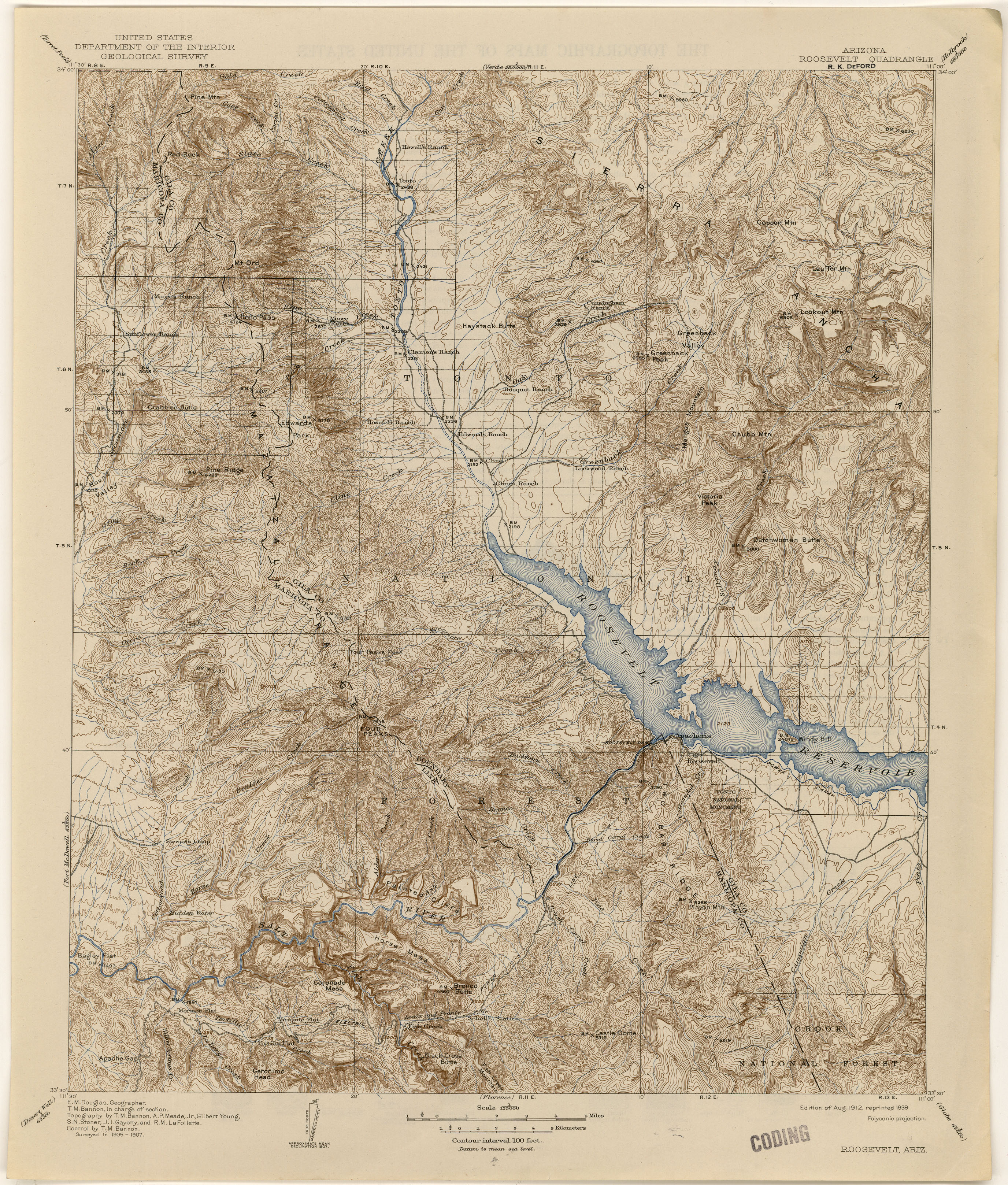
his having a ranch near Coon Bluff.  The landmark "Jones Ford" is shown on a 1904 topo map near Coon's Bluff in what is now the Salt River Recreation Area. In addition to Jones Ford, "Monroy's Ranch" is also shown on the map.  It probably belonged to Alcaria's Tio Poncho. Jones is also reported to have operated another ranch near Hidden Water Spring on Cottonwood Creek north of what is now Saguaro Lake (Butcher Jones Beach).

Remnants of ranch life east of Coon Bluff


In addition to ranching, dabbling in politics and occasionally practicing emergency medicine (bullet wounds & such), he was a prospector and mining speculator. He, from time to time, owned shares in several mines from Prescott to Florence including the famous Vulture Mine. In some circles, it's hinted that he may have known Jacob Waltz of the Lost Dutchman Mine legend.  

Dr. Jones is buried in Double Butte Cemetery, Tempe, AZ.

After the Dr's death in 1896, Colonel Alonzo Ridley acted on the behalf of his estate in probate court. The Colonel was a long-time friend of the Dr's.  He was a confederate in the civil war, refused to agree to surrender, emigrated to Mexico, fought on the side of Maximilian in the Mexican Civil War and worked on the Vera Cruz to Mexico City Railroad before returning to Arizona. Colonel Ridley is another character worth exploring.  (I'll write something of the Colonel later).  After the Colonel's return to the states, he lived on the Jones ranch for several years.  Deputy Sheriff G.G. Gonzales (a well known Tempe lawman, at least back then) was initially assigned as guardian of Jone's children until the Dr's son John could take responsibility.  

The son of Dr. Jones, Johnny Jones, ran the Jones ranching business after the Dr.'s death in 1896. According to Dane Coolidge's book "Arizona Cowboys", Johnny worked very hard to collect and sell enough cattle to provide his sisters with an inheritance. Johnny ran cattle in the western foothills of the Four Peaks Range around the Cottonwood Canyon drainage. 

Western Foothills of the Four Peaks Range


Along with other cattlemen in the early 1900's, he had serious issues with sheep traveling through the range. Between the sheep and cattle, the range became badly overgrazed leading to lack of ground cover and increased erosion. The Salt River dams were being built during that time and there was concern by downstream farmers and the government that the erosion could cause increased sediment at the lakes and dams. The overgrazing ultimately led to the formation of the Tonto National Forest. Sadly, Johnny died of the flu while still in his late 30's.

Abandoned Stock Tank and Cattle Pens along Cottonwood Creek


It's been fun researching this stuff.  I'm looking forward to seeing what else I can find.

Adios


Sunday, February 8, 2015

Some History Lessons - Salt River Recreation Area

The wife has traveled back to Columbus Ohio to visit friends and family.  I'm not really alone though, I've had my youngest grand-daughter to keep me company this weekend.  She's stayed both nights (have I become so old that I require a babysitter?).  Although she mostly has her nose in the Ipad, it's nice to have company for dinner.  She and I have different tastes regarding meals so we compromised and had Taco Bell Friday night and KFC last night.  I'll probably cook breakfast this morning (assuming she gets up before lunch).

I recently read Dane Coolidge's book "Arizona Cowboys".  It was originally published in 1938.  He was a photographer who traveled the West recording flora, fauna and frontier life.  "Arizona Cowboys" is a narrative of his times spent with cowboys and cattlemen in the Arizona of the early 1900's.  It gives a good description of the times and certainly redefines some of the Hollywood notions of rodeo and sheep-cattle conflicts.  The book also explains how overgrazing by sheep and cattle were destroying the grasslands around the Tonto Basin and Salt River watershed leading to erosion problems that could threaten the water projects being developed.  The Tonto National Forest was a direct result.


It turns out that a rodeo was work not sport in the late 1800's and early 1900's.  It was a time when cattle owners got together to gather up their stock.  Not all cattlemen were ranchers, some were just individuals who branded a few head of stock and turned them loose on the open range.  A rodeo was arranged so that all owners could participate in the roundup and be available to identify their branded stock and to claim any new calves belonging to their stock.  By the way, there's still at least one bovine roaming around near Coon Bluff.  I've seen it's tracks and spoor but haven't been around early enough to see it.  By the time I get out, it's probably laying in cover chewing its cud.

The proof may be clearer to those of us who have spent time cleaning up after cattle and also recognize the split hoof print.

One series of the Coolidge stories were recorded in the area along Cottonwood Creek north of what is now Saguaro Lake (the lake appeared 1930).  There were several ranches between Mesa and the Tonto Basin (Roosevelt Lake now).  I believe that the largest was probably the Stewart Ranch (under the lake now at Butcher Jones Beach) but Dr. W.W. Jones and his brother-in-law Francisco "Pancho" Monroy also had ranches in the area.  The Monroy Ranch is shown on 1904 topo maps at a bend in the River near the present day Usery Rd. intersection. I'm not sure of the details yet but Dr. Jones is said to have had a couple places along the river.  There's a Jone's Ford (river crossing, not car showroom) shown near the Verde River, Jones Canyon and Butcher Jones Beach near Saguaro Lake and a Jone's Creek near Cottonwood Creek, these could be clues the locations of Dr' Jone's places.  There are several signs of ranching near this area. The most extensive are near Jone's Ford north of the Forest Service Goldfield admin site.


The Monroy Ranch is shown on the topos as being Southeast of Jone's Ford and it's ranch house is described in "Results_of_Spirit_Leveling_in_Arizona_1899-1909" as being 600' NE of BM1382 PHNX.  I haven't been able to find the benchmark or any sign of a ranch house. Here's what the nearby area looks like.  It's mostly mesquite bosque with a few scattered clearings.


I drove out to Cottonwood Creek via FR104 to see what was left of Stewart's Camp (1907 Roosevelt topo).  It was a locale described in a rodeo story in the Coolidge book.  I took the Beeline Highway east to the turnoff to Four Peaks then drove on to the intersection with FR401.  On the way to Stewart's Camp, not too far along FR401, there's a cattleguard in the roadway and soon afterward a stockyard with an old scales.

Stockyard with scales in background

Stockyards with Superstition Mtn in background


Surprisingly, FR401 was a good road all the way to Cottonwood Creek.  It was, of course, dirt but there were very few potholes and not much washboarding.  There's still a lot remaining of the old stock camp.  The most evident are corrals, a large water tank and some scattered stone/cement foundations.


Sadly, the area hasn't been treated very gently.  Folks had used the rear of the water tank for a toilet and there was graffiti sprayed all over it.  There also appeared to be someone homesteading in their mini-van.  Driving down here I was reminded why I don't do much hiking near Forest Service roads.  As usual, there was a lot of target shooting going on.  Good or bad, it's pretty disconcerting for hikers.

I've been doing a bit of research on some characters of the era and will try and post stuff as I get more info.

Adios