Showing posts with label Tonto National Forest. Show all posts

Saturday, April 25, 2020

Milkweed Map

The Tonto National Forest has been supporting the Monarch Butterfly migration by planting milkweed.  Here in the Sonoran Desert the Mesa Ranger District and volunteer organizations (Friends of the Tonto Nation Forest and Southwest Monarch Study) have been working to increase the population of Desert (Rush) Milkweed (Asclepias  subulata). Milkweed plants are critical to the Monarch Butterfly life cycle because the adults lay their eggs on the plant and the larvae only eat milkweed.

As a volunteer with Friends of the Tonto National Forest (FOTNF), I've participated in planting seedlings in the Tonto NF. Out of my own interest, I've planted milkweed seed in my home gardens and used a phone app to photograph and map milkweed plants.

Update: I added some points (black dots) to the map from Google Maps that I need to verify. I had originally saved them as "Labeled" locations in Google Maps. They don't have photos attached and I'm not sure of the location accuracy.


The photos below are of a Rush (Desert) Milkweed grown from collected seed.

Rush Milkweed in Home Garden

Rush Milkweed in Home Garden
I'm looking forward to collecting more seed this year once the milkweed plants start producing seed pods.

Adios


Monday, April 13, 2020

Tortilla Creek and Hewitt Canyon Riparian Photopoint

A friend and I drove out to Tortilla Flat last week to hike up Tortilla Creek and take photos to support a volunteer project.  The project involves taking photos of the creek and surrounding riparian area at fixed points that can be compared year after year.  The photos are shared with the Forest Service for their use in observing the changes due to erosion, overgrazing or fires in the watershed.  This year's emphasis is on creeks in the watershed effected by the 2019 Woodbury Fire in the Superstition Mountains.  You should be able to find Tortilla Flat on the map below. All of the blue points represent a photopoint site.


The following are photos from Tortilla photopoint #1:


The next photos are from Tortilla #2:


Hiking up the streambed and hoping from rock to rock to cross the creek was tough at some points but it was nice cool day and a pleasure to be out.

Update:
The next week, we drove to Queen Creek and Hewitt Canyon to continue collecting photos of the riparian areas. We first drove out Hewitt Station Road on Forest Service Road (FSR) 357 to the turnoff to Hewitt Canyon and the Queen Creek crossing of FSR 172.  We had two sites on Queen Creek: one at the road crossing and another a few hundred feet upstream where Hewitt Creek entered Queen Creek.

Queen Creek at Road Crossing
Queen Creek at Confluence with Hewitt Creek

We continued up Hewitt Canyon Road (FSR 172) and took photos at 3 sites along Hewitt Creek.  The road was unpaved and rough in spots but was easily traveled with a high clearance pickup truck. We found the first two sites relatively easy but the directions to the third were a bit confusing. Once we found the third spot, its location was obvious due to the stone enclosure clearly seen from the road.

First Site on Hewitt Creek 
Second Site on Hewitt Creek

Third Site on Hewitt Creek


Landmark for Third Site

We got the photos at the right time. The temperatures the next were in the 90's and a brush fire near Hewitt Canyon had limited access to the area.

That may finish the photopoints for 2020 unless Apache Trail opens up beyond Fish Creek Canyon. I have the documents for Fish Creek and Lewis & Pranty Creek but the sites are relatively inaccessible until the road opens.

Adios

Tuesday, November 26, 2019

Jones Wash

I finally got around to hiking up the ridge on the north side of Saguaro Lake. I parked at the Butcher Jones Beach overflow parking lot and walked through a mesquite bosque into the wash bordering the ridge. The wash runs east to west along north facing bluffs of the ridge.

Jones Wash
The north facing bluffs provided shelter from the intense Sonoran Desert sun for communities of liverworts, mosses and ferns.
Thallus Liverwort
The ridge is composed of conglomerate and tuff (welded ash) laid down during and after volcanic activity in the middle tertiary period (10-20 Mya).

From ridge looking down into wash
There are several wet weather stream beds draining the ridge. The small stream below contained water from recent rains.

Wet Weather Stream

The north facing slope also included shaded areas that supported ferns, mosses and spiked club moss.

Wright's Lipfern


Star Cloak Fern and Spiked Club Moss
I've always been attracted to north facing slopes because they support such a large diversity of plant types and isolated communities of plant life dependent on shade and moisture.  There are other places in this vicinity that I want to explore on future walks.

Revised 11/28/2019

I returned to the wash a few days later and continued upstream for a mile or so. The wash was wide and unobstructed with nice views of surrounding mountains. There were also numerous deer tracks and game trails cutting the wash.


About a half mile from the parking area there was a point where the wash had long ago cut through a sandstone and conglomerate ridge leaving tall bluffs on each side of the wash.  The bluffs were riddled with caves. The cave are good shelter for animals and have probably also been shelter for people.


I want to return again soon but park along a side canyon, hike across the large wash and explore some game trails.

Adios

Sunday, November 10, 2019

Trailcam

I finally bit the bullet and bought an inexpensive trailcam a few weeks ago.  I'd hesitated because the models that I'd seen previously seemed too expensive for me to leave along the trail. I bought a $30 Tasco thinking that I wouldn't be too upset if it was lost. I needed to invest an additional $20 in batteries (8 lithium) and a memory card (16Gb Sandisk).  The first time I set it up for 5 days overlooking a game trail in the Tonto National Forest but didn't capture any wildlife.  I did get a couple of selfies and 1,200 photos of a branch waving in front of the lens.


Important lessons were learned from the first trial: 1) always look your best, 2) don't count on much wildlife unless there are plenty of recent signs, 3) clear out all brush from in front of the camera. This second trial worked out much better and the camera caught a small band of Javelina and no waving branches.


I should still work on my appearance since rude comparisons were made to Sasquatch.


I plan to set it up again next week. We'll see what shows up.

Adios

Friday, November 8, 2019

Whitford Canyon

A friend and I spent a day roaming around Whitford Canyon taking photos for a riparian project.  It involved several miles of travel on sometime rough forest service roads and short hikes along Whitford Wash. We pulled off of US 60 directly across from Boyce Thompson Arboretum onto FS 357 then onto FS8 (E Happy Camp Rd.). We eventually turned onto FS650 (N Happy Camp Rd.) where we spent most of our travels.  The roughest piece of road was the turnoff to Barnett Camp (FS 982). It was narrow and rough but passable in a high clearance 2WD truck. At the crossing with Whitford Wash we parked at an old perlite quarry and hiked down the wash for some photos.

Looking downstream on Whitford Wash at hiking buddy.. Perlite mine at upper right.

The photos are to support a project organized by Friends of the Tonto National Forest. The project involves having volunteers travel to selected riparian areas in the Tonto National Forest to take photos at the same locations on successive years. The goal is to track changes in riparian vegetation due to grazing, climate and flooding. The Whitford Canyon sites were chosen for attention this year because the region near the creek's headwaters was burned during a large fire (Woodbury Fire) the previous summer. It is expected that the area may be impacted by flash flooding due to lack of ground cover in the burn area.

I picked up a perlite sample and some chalcedony nodules from near the perlite quarry.

Perlite sample at bottom, chalcedony nodules above

We hiked farther upstream in the canyon to get to the next photo locations. In this area, Whitford Canyon is bounded by bluffs composed of Dripping Springs Quartzite formed from sandstone and conglomerate during the middle Proterozoic era. The Dripping Springs Quartzite formation contains many distinct beds of red-brown quartzose sandstone and pebbled conglomerate. Some of the layers are clearly cross bedded as if formed by wind blown sand.

Dripping Springs Quartzite

Dripping Springs Quartzite (see cross bedding at base)

Dripping Springs Quartzite

We returned to the truck and bounced back along FS982 to return to FS650 and continue north along the canyon to the furthest upstream site. It was located along the upper portion of Whitford Creek and accessed via a section of the Arizona Trail. This portion of the canyon changed from the dramatic quartzite cliffs to more open country and large blocks of older Pinal Schist from the early Proterozoic era.

Pinal Schist

Looking upstream along Whitford Wash

Pinal Schist

Our next stop required backtracking on FS650 until the next crossing of the Arizona Trail. We parked nearby and proceeded along the Arizona Trail downstream to the next location. Along the way we saw some stone wall that looked very old but it's purpose wasn't clear. There was a lot of old discarded lumber nearby so it might have been ranching related or possibly the wall was originally built by prehistoric native peoples.

Old Stone Wall

The next photo locations were downstream in a rugged canyon surrounded by quartzite cliffs.  We hiked through dense stands of mesquite and past several old dead cottonwoods.  Unfortunately, our directions to the locations were 12-18 years old and some portions of the trail and wash had shifted over the years.  We made our best guesses and took photos as near to described as possible then returned to the truck.

Whitford Canyon looking downstream

Whitford Canyon looking upstream.
After a long hot bumpy ride back to US60, we drove up to the town of Superior for a beer and burger at Porter's Cafe.

Adios

Wednesday, February 8, 2017

An Unrepentant Rebel: Colonel Ridley - Lower Salt River Recreation Area

Among the characters roaming the vicinity of the Lower Salt River Recreation Area, Colonel Alonzo Ridley was one of the most interesting.  As I've discussed previously, Dr. W.W. Jones lived and ranched in the Salt River and Tonto areas in the late 1800's.  The Colonel was a good friend of the Doctor and sometimes kept the Doctor company at the ranch.


Alonzo Ridley immigrated to California from Maine in 1849 seeking his fortune in the gold fields. In the 1850's, he evidently gave up on mining and moved down to the village of Los Angeles where he became an Indian agent on the Tejon Reservation. He later served as under-sheriff in Los Angeles County and it was in Los Angeles where he first met Dr. W. W. Jones.

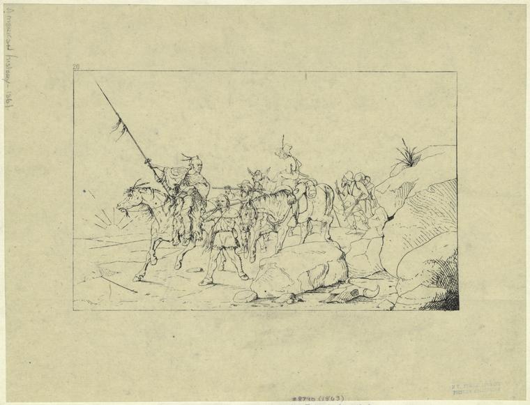
The Colonel's most notable adventure was the escort of General Albert Sidney Johnston from California to Texas.  Albert Sidney Johnston was an experienced soldier, a graduate of West Point and recently commander of the U.S. Army's Department of the Pacific.  Johnston had resigned from the U.S. Army at the beginning of the Civil War and settled as a neutral in Los Angeles.  Eventually, Johnston feared that he would be arrested by Union authorities and so decided to travel to Texas.  Ridley chose the confederate cause while in California where he organized and commanded a militia of like minded men to escort General Johnston to Texas to join the Confederate Army.

Index
Art and Picture Collection, The New York Public Library. "Albert S. Johnston Crossing The Desert To Join The Southern Army." The New York Public Library Digital Collections. 1863. http://digitalcollections.nypl.org/items/510d47e0-f92a-a3d9-e040-e00a18064a99

In 1861, scouts commanded by Captain Ridley led the way across the southern California deserts and across the Colorado River at Yuma.  From the Colorado, they traveled up the Gila River to the Pima villages near present day Phoenix then down the Santa Cruz to Tucson. They continued their trek across Arizona and New Mexico while carefully avoiding Apaches and the Union Army until safely reaching El Paso where the militia was disbanded.

Ridley served as General Johnston's bodyguard at the battle for Shiloh where Johnston was fatally wounded. Afterward, he trained in Texas as an engineer and eventually became a Lieutenant Colonel in the Confederacy but he was captured at Fort Butler in Louisiana in 1863 and was imprisoned until the end of the war.

Index
Art and Picture Collection, The New York Public Library. "Retreat of the confederates from Shiloh." The New York Public Library Digital Collections. 1905. http://digitalcollections.nypl.org/items/510d47e0-f96e-a3d9-e040-e00a18064a99

  After the war he didn't sign the pardon agreeing to surrender but instead emigrated to Mexico and fought on the side of Maximilian in the Mexican Civil War. He lived in Mexico for several years and was employed by a British company responsible for building the Vera Cruz to Mexico City railroad.

In 1877 he returned to the states and met Dr. Jones while Jones was working a gold mill on the Hassayampa River near Wickenburg. He became good friends with Dr. Jones and resided with him many times over the years. In 1885, Dr. Jones and Colonel Ridley were described as entertaining hosts by expedition members traveling down the Salt River. The travelers had reportedly stopped for the night at the Jones ranch just above the Verde River confluence in what is now the Lower Salt River Recreation Area. It's my best guess that the ranch was located near what is now a Forest Service facility on N. Usery Pass Rd.

The Colonel didn't consider himself a citizen of the US. He was a citizen of the Empire of Mexico and referred to himself as such. However, he was required to take the oath of allegiance and become a US citizen in order to be the executor of Dr. Jone's estate in 1896. It says much of their friendship that the old rebel finally took the oath. After settling the estate, he traveled to Havana, Cuba but returned to Arizona after a couple of years. He died in Tempe in 1909 and is buried at Double Butte Cemetery.

Image result for colonel alonzo ridley

References:
Texas Sate Historical Assoc., https://tshaonline.org/handbook/online/articles/fri57
Gene C. Armistead, "California's Confederate Militia: The Los Angeles Mounted Rifles,"
Daily Phoenix Herald, June 5, 1885, "A Daring Expedition".
Arizona Republican, July 16, 1896, pg 5.
Arizona Republican, March 26, 1909

Sunday, January 29, 2017

Ussery Park's Namesake: King Ussery - Salt River Recreation Area


Usery Regional Park is reportedly named after King Ussery a locally famous cowboy, livestock thief and stage robber. He was reportedly a handsome, well liked guy and he must have had some charm to get a mountain range and park named after him. He was born in 1869 and grew up in the Tonto Basin. According to some accounts, he may have also run a few stray cattle on the range near Usery Mountain and the Salt River Recreation Area. He was described in an 1899 newspaper as being "the most notorious, if not the most desperate criminal in Arizona."  No wonder they named a park after him.

In December of 1891, according to the St. Johns Herald, the Globe-Florence (Riverside) stage was stopped by a highwayman in Pinal County who demanded the express box.  He ordered the stage to proceed after being told there was no bullion aboard. The highwayman was identified as King Ussery. Ussery was a small-time cattleman in the Tonto country and according to delinquent tax notices owned a ranch 12 miles up Tonto Creek.

In January 1892, the Globe-Florence stage was again held up in Pinal County and $2,400 worth of bullion was stolen. The highwayman could not be identified but the trail of two horses was followed 50 miles to the corral of Henry Blevins (a friend of Ussery). A bar of of bullion was subsequently recovered from the nearby Salt River.  Blevins was tried by jury and released.

Ussery kept ahead of the law for a long time by hiding in the Tonto country where he grew up.  Eventually, Sheriff J.H. Johnson of Gila County caught Ussery by circling from Globe through Greenback Valley at night to Tonto and staking out King Ussery's mother's home. After capturing his brother, the Sheriff convinced King Ussery to give up. (Side note: In our Air Force orientation class in Lackland AFB back in 1974, the drill sergeant informed us that if we went AWOL he would know where to find us. "When in trouble all boys run back to their mother").  The Arizona Silver Belt also reported on the robbery and added references to Gila County horse theft and a federal charge of mail theft.

Sheriff Thompson and Frank Prothero brought 23 year old King Ussery to Globe for trial. He received a sentence of 7 years at Yuma Territorial Prison.

File:Yuma3-13-04 (16).jpg
Yuma Territorial Prison

He was pardoned in 1894 after appeals from his mother and a review of new evidence that seemed to exonerate him. After his pardon, he evidently changed his ways and shifted to cattle rustling. He received a light sentence in Gila County for the theft and then left the area.

In 1898, Ussery was found not guilty by a jury in the robbery of the Gladiator Mill in Prescott.

In 1899, he shifted to horse stealing. He visited his uncle, a race horse breeder in the Tonto area (John L. Cline), and succeeded in convincing him to let King take a test drive. King then took off for California riding one race horse and leading another. Cline finally recovered one of the horses near the Colorado River but King continued onward with the other. When finally caught in Mammoth, AZ, Ussery was sentenced to 10 more years at Yuma.

Also in 1899, he was arrested near Cave Creek for stealing horses from Jesus Madrial in Yavapai County.

He was also under indictment in Yavapai County for grand larceny.  He was suspected of having robbed a stage several miles southwest of Prescott.  Another man was arrested and jailed for the robbery but Ussery was reported to have helped in his defense and finally admitted to the crime while in prison for the Tonto area horse theft.  The governor became suspicious of the circumstances after learning that the man and Ussery were close friends.  Instead of pardoning him he cut several years off of the man's sentence.

The Arizona Miner (Prescott) reported in July of 1903 that Ussery had sent a hand tooled bridle to Sheriff Roberts with a request for him to sell it to raise some money in anticipation of Ussery's anticipated release from prison.  The bridle was described as being black leather with silver mountings and artistically plaited leather reins. He was finally released around 1903 at the ripe old age of 33.

He must have decided to look for greener pastures after his pardon because it appears that he's buried in King Co., Washington after dying of acute pulmonary edema in 1941. After his pardon, I couldn't find any references to King Ussery, other than his obit.  His death certificate listed his occupation as "miner". Maybe he reformed.

References:
(from Library of Congress, Chronicling America website)
Arizona Republican, Friday January 29, 1892
Arizona Silver Belt, February 27, 1892
St. Johns Herald, Thursday February 4, 1892
S. Johns Herald, Thursday December 8, 1892, pg. 1
Arizona Republican, October 20, 1894, pg. 1
Arizona Republican, Friday December 22, 1899, pg. 5
Arizona Republican, Monday December 25, 1899, pg. 3
Arizona Republican, Sunday November 19, 1899, pg. 3
Arizona Weekly Journal-Miner, November 22, 1899
Arizona Weekly Journal-Miner, January 31, 1900
Arizona Republican, Wednesday June 11, 1902, pg. 1
Arizona Journal-Miner, July 1, 1903

Friday, January 1, 2016

Francisco "Pancho" Monroy - Salt River Recreation Area

My favorite place for strolling around in the desert is along the Salt River near the junction with the Verde River in the Tonto National Forest.  The area was much busier in the early 20th century when it was still open range and before Tonto National Forest was created.  Old maps show locations of abandoned mines and ranches that are no longer visible on modern maps.  One such site called Monroy's Ranch is shown on a 1904 U.S. Geological Survey map. The ranch is shown west of Blue Point on the south side of the Salt River. The Tonto National Forest Foxtail Administrative Site (located just east of the Usery Rd./Bush Hwy. intersection) is presently at the approximate Monroy Ranch location. Some initial research identified the ranch with Francisco "Pancho" Monroy.


Portion of 1904 USGS Map Showing Monroy Ranch Location

Francisco "Pancho" Monroy is mentioned in Dana Coolidge's book (reference 1), "Arizona Cowboys" as an uncle of Johnny Jones who was the son of Dr. W.W. Jones (an Arizona pioneer and one-time business associate of the Goldwater brothers). He is described in the book as an old-time Mexican cowman originally from Caborca, Sonora. Coolidge had visited the ranch with Johnny Jones prior to publishing his book. Coolidge maintained that visitors were always welcome at Monroy's home.


According to Coolidge, Monroy had been at the ranch for 30 years and had fought off Apaches and lived through droughts and disasters.  However at the time of the author’s visit in 1904, his pastures had been decimated by sheep due to his close proximity to the main sheep crossing on the Salt River. It’s reported that ninety thousand sheep crossed the Salt River near Blue Point and Monroy's Ranch twice a year during the early 1900's.  By 1904, the only stock remaining on the ranch consisted of a few goats.  


The book contains a couple of photos of Monroy.  One of which shows him looking upriver from a high bluff along the Salt River.  If you climb the bluff to the west of the ranch site, the view still looks much the same (see below).


Looking East through Salt River Valley (Monroy Ranch area below bluff)

Reference 1: Arizona Cowboys, Dane Coolidge, University of Arizona Press, Tucson Arizona, 1984.

There is also a photo of Pancho Monroy sitting at his ranch stored in the Arizona State Archive photo collection.

A search for Monroy Ranch in the Chronicling America newspaper search site brings up several Arizona Republican articles mentioning the site over the years 1910 to 1918 (search Monroy Ranch or Francisco Monroy).  Some of these articles relate to local folks camping at the ranch on fishing and hunting trips and others refer to the ranch as a geographical reference point. However, another Arizona Republican article in the August 11, 1918 edition page 10 describes Francisco as being tortured and robbed by heavily armed bandits at his ranch near Blue Point. The article describes five heavily armed men riding up to the ranch and requesting water. When Francisco attempted to get the water they jumped him and tied him up. The bandits suspected that he had hidden money and tortured him with knives trying to get him to tell them the location. Finally, Francisco's wife gave the locations to the bandits and they got off with around $1,500 worth of gold hidden in the house.
Reference link:  http://chroniclingamerica.loc.gov/

According to the book, “Mexicans in Tempe”, Francisco was born in the mid 1880’s and worked as a vaquero on Dr. W.W. Jones’s Blue Point Ranch. It's evident that Dr. Jones ranched in the area considering the location of "Jone's Ford" of the Salt River located just downstream from Monroy's Ranch (see 1904 map).

Monroy is also mentioned in the book "Images of America, Apache Junction and the Superstition Mountains". There is also a photo of him included in the book. Monroy is mentioned in this book and in Lost Dutchman discussion forums as having been a host to Jacob Waltz (Lost Dutchman) as Jacob traveled along the Salt River on prospecting trips. Monroy Ranch is also mentioned as being near the Government Trail river ford that is mentioned in some Lost Dutchman discussions.

Things must have been very interesting during those times.

This summer, when its too hot to for outdoor exploring, I'll explore the library for more material and update this blog.

Adios


Photos of landscape at location of Monroy Ranch.

Clearing near ranch area


Clearing near ranch area

Clearing near ranch area

Road to the river

View over ranch area towards west