Sunday, November 10, 2019

Trailcam

I finally bit the bullet and bought an inexpensive trailcam a few weeks ago.  I'd hesitated because the models that I'd seen previously seemed too expensive for me to leave along the trail. I bought a $30 Tasco thinking that I wouldn't be too upset if it was lost. I needed to invest an additional $20 in batteries (8 lithium) and a memory card (16Gb Sandisk).  The first time I set it up for 5 days overlooking a game trail in the Tonto National Forest but didn't capture any wildlife.  I did get a couple of selfies and 1,200 photos of a branch waving in front of the lens.


Important lessons were learned from the first trial: 1) always look your best, 2) don't count on much wildlife unless there are plenty of recent signs, 3) clear out all brush from in front of the camera. This second trial worked out much better and the camera caught a small band of Javelina and no waving branches.


I should still work on my appearance since rude comparisons were made to Sasquatch.


I plan to set it up again next week. We'll see what shows up.

Adios

Friday, November 8, 2019

Whitford Canyon

A friend and I spent a day roaming around Whitford Canyon taking photos for a riparian project.  It involved several miles of travel on sometime rough forest service roads and short hikes along Whitford Wash. We pulled off of US 60 directly across from Boyce Thompson Arboretum onto FS 357 then onto FS8 (E Happy Camp Rd.). We eventually turned onto FS650 (N Happy Camp Rd.) where we spent most of our travels.  The roughest piece of road was the turnoff to Barnett Camp (FS 982). It was narrow and rough but passable in a high clearance 2WD truck. At the crossing with Whitford Wash we parked at an old perlite quarry and hiked down the wash for some photos.

Looking downstream on Whitford Wash at hiking buddy.. Perlite mine at upper right.

The photos are to support a project organized by Friends of the Tonto National Forest. The project involves having volunteers travel to selected riparian areas in the Tonto National Forest to take photos at the same locations on successive years. The goal is to track changes in riparian vegetation due to grazing, climate and flooding. The Whitford Canyon sites were chosen for attention this year because the region near the creek's headwaters was burned during a large fire (Woodbury Fire) the previous summer. It is expected that the area may be impacted by flash flooding due to lack of ground cover in the burn area.

I picked up a perlite sample and some chalcedony nodules from near the perlite quarry.

Perlite sample at bottom, chalcedony nodules above

We hiked farther upstream in the canyon to get to the next photo locations. In this area, Whitford Canyon is bounded by bluffs composed of Dripping Springs Quartzite formed from sandstone and conglomerate during the middle Proterozoic era. The Dripping Springs Quartzite formation contains many distinct beds of red-brown quartzose sandstone and pebbled conglomerate. Some of the layers are clearly cross bedded as if formed by wind blown sand.

Dripping Springs Quartzite

Dripping Springs Quartzite (see cross bedding at base)

Dripping Springs Quartzite

We returned to the truck and bounced back along FS982 to return to FS650 and continue north along the canyon to the furthest upstream site. It was located along the upper portion of Whitford Creek and accessed via a section of the Arizona Trail. This portion of the canyon changed from the dramatic quartzite cliffs to more open country and large blocks of older Pinal Schist from the early Proterozoic era.

Pinal Schist

Looking upstream along Whitford Wash

Pinal Schist

Our next stop required backtracking on FS650 until the next crossing of the Arizona Trail. We parked nearby and proceeded along the Arizona Trail downstream to the next location. Along the way we saw some stone wall that looked very old but it's purpose wasn't clear. There was a lot of old discarded lumber nearby so it might have been ranching related or possibly the wall was originally built by prehistoric native peoples.

Old Stone Wall

The next photo locations were downstream in a rugged canyon surrounded by quartzite cliffs.  We hiked through dense stands of mesquite and past several old dead cottonwoods.  Unfortunately, our directions to the locations were 12-18 years old and some portions of the trail and wash had shifted over the years.  We made our best guesses and took photos as near to described as possible then returned to the truck.

Whitford Canyon looking downstream

Whitford Canyon looking upstream.
After a long hot bumpy ride back to US60, we drove up to the town of Superior for a beer and burger at Porter's Cafe.

Adios

Tuesday, July 30, 2019

Salt River Terraces


I just read an interesting article [1] regarding ancient terraces on the lower Salt River. I was well acquainted with four of the terraces; Sawick, Mesa, Blue Point and Lehi. The first three are easily found in the Lower Salt River Recreation Area.  The Sawick terrace is the oldest and is found on top of the Mesa Terrace, both of which are situated on the Blue Point terrace.


The Coon Bluff and Phon D. Sutton parking areas lie on the Blue Point terrace. The three oldest terraces are accessible from the Phon D. Sutton parking area and from Bush Hwy southeast of the Usery Rd. intersection.  The terraces are considered “scarp” terraces because they were formed by cutting through bedrock. The cutting through bedrock may be related to uplift of the mountainous transition zone to the east. The gravels on the Sawick and Mesa terrace are well cemented by caliche. The Sawick terrace is estimated to have been excised 1-2 million years ago [2].

On Mesa Terrace with higher Sawick Terrace in immediate background

Looking down from Mesa Terrace to Blue Point Terrace

Gravels cemented with caliche on Mesa Terrace
The 2010 article reports findings describing another older and higher terrace named the Stewart Mountain Terrace. Characteristics of the gravel hint at different flow of the Salt River when it was formed. The new terrace was discovered at 1870' on the north side of the Salt River southwest of Stewart Mountain and east of the Verde River. The types of gravels found on the new terrace suggest ancient river flow different from the current floodplain.

The most interesting fact for me is that the proposed new terrace suggests that the river was once at a much higher elevation (approx 500' higher) and much wider than the current river. That's a lot of river.

Another mechanism discussed is that the terrain may have been 500' lower millions of years ago. As the terrain rose, the river could have cut successively lower terraces.


[1] STEWART MOUNTAIN TERRACE: A NEW SALT RIVER TERRACE WITH IMPLICATIONS FOR LANDSCAPE EVOLUTION OF THE LOWER SALT RIVER VALLEY, ARIZONA, September 2010, PHILLIP H.LARSON,RONALD I.DORN, School of Geographical Sciences and Urban Planning, Arizona State University, PO Box 875302, Tempe, AZ 85287-5302; JOHN DOUGLASS, Department of Geography, Paradise Valley Community College, 18401 N 32nd St,Phoenix, AZ 85032; BRIAN F. GOOTEE, Arizona Geological Survey, 416 W Congress St., Ste 100, Tucson, AZ 85701-1381;and RAMON ARROWSMITH, School of Earth and Space Exploration, Arizona State University, PO Box 871404, Tempe, AZ 85287-1404

[2] TERRACES OF THE LOWER SALT RIVER VALLEY IN RELATION TO THE
LATE CENOZOIC HISTORY OF THE PHOENIX BASIN, ARIZONA, by Troy L. Pewe, Guidebook to the Geology of Central Arizona, 1978.


Saturday, November 3, 2018

Interactive Map (Updated Automatically, Ignore date on page)

I'm still messing around with mapping my aimless wandering.  This map was generated from Google Maps. I imported Epicollect data from my walks into Google Fusion and exported filtered data in KML files. The files were then imported into Google Maps as layers which were then color and assigned with appropriate icons.  Next HTML was generated from Maps and embedded into this site. (11-20-2018: Updated map with additional data and revised icons)


Thursday, March 23, 2017

Arizona Barite Mine - Lower Salt River Recreation Area

I don't know why I delayed writing about Arizona Barite for so long. It's one of the first locations that interested me.  I'm drawn up there at least a couple of times each year.  It's really hard to miss because the highwall of the above ground section is clearly visible on the south side of Coon Bluff from Bush Highway.


According to Arizona Department of Mines and Mineral Resources (ADMMR) documentation (now at Arizona Geological Survey (AZGS)), the mine was developed sometime in 1931 by W. F. Christman to obtain barite ore deposited along a fault running NW to SE along Coon Bluff. The highwall shown above runs along this fault. Barite is a heavy mineral used primarily in oil drilling "mud" because it helps the lubricating fluid sink during drilling. Christman obtained the original 1897 claims from owners who were earlier prospecting for silver. The mine has been known by several names over the years: Phoenix Group, Granite Reef, Chrisman Barite, Mesa Barite Claims, Macco and Granite Reef Dam.

Headframe - AZGS File 394

A 1945 survey map shows the vertical shaft reaching 320 feet and the locations of several open cuts including the southeastern one visible today from the Bush Highway.  There seems to have been a lot of correspondence during 1941-1945 concerning obtaining federal funds for operating expenses. An argument was being made regarding the need for barite to support the war effort. Mining continued until 1955 when decreased quality of the ore and heavy flows of underground water caused the operations to end.

From File 394, AZGS 

In 1970, the Forest Service notified the representative of the current claim owners of public safety hazards at the site including open shafts and thinly covered underground workings.  The letter asked for the cooperation of the owners in supporting mitigation of the hazards.  An unsigned 1982 correspondence in the AZGS (ADMMR) file indicates that the property has been bladed and shafts and pits blasted shut.

The workings must have opened up a bit over the years because by the time I was poking around the area in the mid 2000's a deep hole along the fault was clearly present.  The video below shows an opening into the workings that I recorded in 2007.

2007 Open Shaft


A covering of chain link fencing had been added by 2013
Currently the main shaft is covered by what appears to be a bat accessible cover.  It would be helpful if the Forest Service could install some sort of informational plaque to explain the design and function.

Current Shaft Covering

Hikers should be aware that there are still a few hazards left in the area.  There are two nearby prospect holes that are deep enough for a nasty fall.

Prospect Hole SW of Site
Prospect Hole SE of Site


The area is easily accessible by following a horse trail from the parking lot at the Phon D. Sutton & Bush Highway intersection.  Follow the horse trail approximately 3/8 mile east until a faint road appears to the left leading north to a pass.  The old road will lead into the mine area.


References:
Arizona Geological Survey, Arizona Barite, File 394
U.S. Department of the Interior, Bureau of Mines, "Barite Deposits of Arizona", L.A. Stewart & A.J. Pfister, 1960, pg. 38.

Sunday, March 5, 2017

Little LaDonna Prospect - Lower Salt River Recreation Area

The Little LaDonna was classified as a "prospect" by the Arizona Dept. of Mines because it probably never produced any commercial ore.  The claim includes several prospect holes and a filled-in shaft.  The records include a few notes indicating that samples were submitted in 1985 that contained copper ores.  It's no longer active since mining is now prohibited in the area.

Location of Little LaDonna shown in Google Earth

The site is located in Township 2 north, Range 7 east in the Lower Salt River Recreation Area of Tonto National Forest.  The commodities listed are copper minerals and gold.  I treat the gold claim with a lot of skepticism.  However, I have picked up samples in the area with copper stains.


Copper Oxide Stain on Quartz

The shaft originally had a partial headframe but that's been removed in the last few years.

Shaft with Partial Headframe (upper right)

There are prospects holes scattered around several of the nearby hills.  Most include quartz stained with hematite.


There's also lots of abandoned mining equipment scattered around the site.


It's an interesting area to explore but watch out for nails in lumber and various prospect holes scattered around waiting to be stepped in.

Adios

Wednesday, February 8, 2017

An Unrepentant Rebel: Colonel Ridley - Lower Salt River Recreation Area

Among the characters roaming the vicinity of the Lower Salt River Recreation Area, Colonel Alonzo Ridley was one of the most interesting.  As I've discussed previously, Dr. W.W. Jones lived and ranched in the Salt River and Tonto areas in the late 1800's.  The Colonel was a good friend of the Doctor and sometimes kept the Doctor company at the ranch.


Alonzo Ridley immigrated to California from Maine in 1849 seeking his fortune in the gold fields. In the 1850's, he evidently gave up on mining and moved down to the village of Los Angeles where he became an Indian agent on the Tejon Reservation. He later served as under-sheriff in Los Angeles County and it was in Los Angeles where he first met Dr. W. W. Jones.

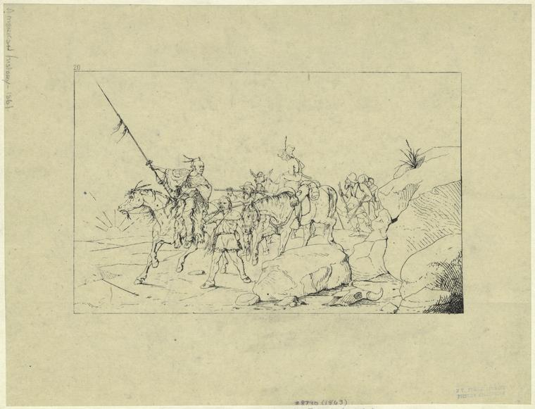
The Colonel's most notable adventure was the escort of General Albert Sidney Johnston from California to Texas.  Albert Sidney Johnston was an experienced soldier, a graduate of West Point and recently commander of the U.S. Army's Department of the Pacific.  Johnston had resigned from the U.S. Army at the beginning of the Civil War and settled as a neutral in Los Angeles.  Eventually, Johnston feared that he would be arrested by Union authorities and so decided to travel to Texas.  Ridley chose the confederate cause while in California where he organized and commanded a militia of like minded men to escort General Johnston to Texas to join the Confederate Army.

Index
Art and Picture Collection, The New York Public Library. "Albert S. Johnston Crossing The Desert To Join The Southern Army." The New York Public Library Digital Collections. 1863. http://digitalcollections.nypl.org/items/510d47e0-f92a-a3d9-e040-e00a18064a99

In 1861, scouts commanded by Captain Ridley led the way across the southern California deserts and across the Colorado River at Yuma.  From the Colorado, they traveled up the Gila River to the Pima villages near present day Phoenix then down the Santa Cruz to Tucson. They continued their trek across Arizona and New Mexico while carefully avoiding Apaches and the Union Army until safely reaching El Paso where the militia was disbanded.

Ridley served as General Johnston's bodyguard at the battle for Shiloh where Johnston was fatally wounded. Afterward, he trained in Texas as an engineer and eventually became a Lieutenant Colonel in the Confederacy but he was captured at Fort Butler in Louisiana in 1863 and was imprisoned until the end of the war.

Index
Art and Picture Collection, The New York Public Library. "Retreat of the confederates from Shiloh." The New York Public Library Digital Collections. 1905. http://digitalcollections.nypl.org/items/510d47e0-f96e-a3d9-e040-e00a18064a99

  After the war he didn't sign the pardon agreeing to surrender but instead emigrated to Mexico and fought on the side of Maximilian in the Mexican Civil War. He lived in Mexico for several years and was employed by a British company responsible for building the Vera Cruz to Mexico City railroad.

In 1877 he returned to the states and met Dr. Jones while Jones was working a gold mill on the Hassayampa River near Wickenburg. He became good friends with Dr. Jones and resided with him many times over the years. In 1885, Dr. Jones and Colonel Ridley were described as entertaining hosts by expedition members traveling down the Salt River. The travelers had reportedly stopped for the night at the Jones ranch just above the Verde River confluence in what is now the Lower Salt River Recreation Area. It's my best guess that the ranch was located near what is now a Forest Service facility on N. Usery Pass Rd.

The Colonel didn't consider himself a citizen of the US. He was a citizen of the Empire of Mexico and referred to himself as such. However, he was required to take the oath of allegiance and become a US citizen in order to be the executor of Dr. Jone's estate in 1896. It says much of their friendship that the old rebel finally took the oath. After settling the estate, he traveled to Havana, Cuba but returned to Arizona after a couple of years. He died in Tempe in 1909 and is buried at Double Butte Cemetery.

Image result for colonel alonzo ridley

References:
Texas Sate Historical Assoc., https://tshaonline.org/handbook/online/articles/fri57
Gene C. Armistead, "California's Confederate Militia: The Los Angeles Mounted Rifles,"
Daily Phoenix Herald, June 5, 1885, "A Daring Expedition".
Arizona Republican, July 16, 1896, pg 5.
Arizona Republican, March 26, 1909